Helene weakened to a tropical storm early Friday morning, but continues on its destructive path as it moves over Georgia and the Tennessee Valley. This is one of the most powerful storms to ever hit the U.S., with fears of widespread devastation and deaths mounting in its wake.
At least four deaths have been reported following the storm’s landfall.
“When we wake up tomorrow morning, the chances are there will likely have been more fatalities,” said Florida Governor Ron DeSantis in one of his many hurricane updates late Thursday. DeSantis confirmed the death of a driver whose car was struck by debris.
Two others died in south Georgia as a possible tornado hit the area. Another was reported dead in Charlotte, North Carolina, when a tree fell on a home during the storm on Friday, according to The Associated Press.
MUST SEE: The Weather Network’s hurricane hub for the latest updates on all tropical activity
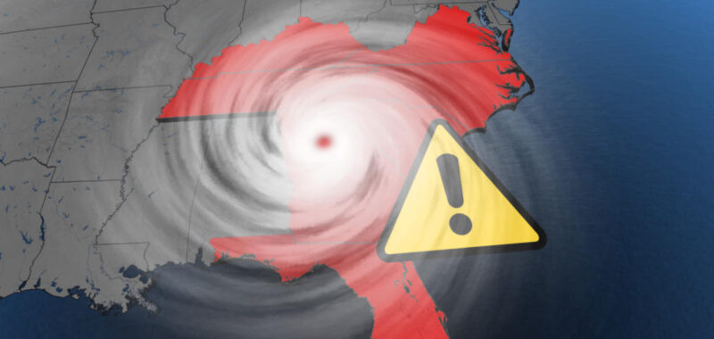
Helene made landfall near Perry, Florida, at 11:10 p.m. EDT on Thursday as a major Category 4 hurricane with maximum sustained winds of 225 km/h. This was the strongest storm in history to make landfall in the Big Bend region.
Close to one million customers were without power even before Helene’s arrival, with that number easily doubling by Friday morning. Severe flooding, and swamped neighbourhoods have been reported in several coastal areas. Water sensors in Cedar Key, Fla., measured nearly 2.5 metres of storm surge shortly before landfall on Thursday. A record height of 2.8 metres was recorded for the region.

All hurricane and tropical storm warnings have been dropped along the Florida east coast, south of the Flagler/Volusia county line, and along the Florida west coast south of the mouth of the Suwannee River. The hurricane warning for the Florida coast from the mouth of the Suwannee Rover to Mexico Beach has been changed to a tropical storm warning.
As of Friday morning, the storm surge warning remained in effect for Tampa Bay, and Indian Pass to Bonita Beach.
Although Helene is expected to continue weakening, likely becoming a post-tropical low by Friday night, winds, heavy rains, and life-threatening storm surges remain a major concern.
“The deepest water will occur along the immediate coast near and to the east of the landfall location, where the surge will be accompanied by large and dangerous waves,” said the U.S. National Hurricane Center (NHC) in Friday morning’s update. “Surge-related flooding depends on the relative timing of the surge and the tidal cycle, and can vary greatly over short distances.
In several areas, water was still expected to reach at least 1.5 metres.
Officials had called this an “unsurvivable scenario” in coastal areas, with water capable of destroying buildings and carrying cars. Several storm surge records were broken, including Tampa Bay where heights reached 2.1 metres, beating the previous record of 1.7 metres.

Additional rain could result in catastrophic and potentially life-threatening flash flooding
Helene’s maximum sustained winds were still howling at 110 km/h early Friday. On its forecast track, a turn toward the north is expected, taking the centre of Helene over central and northeastern Georgia.
“After that, Helene is expected to turn northwestward and slow down over the Tennessee Valley later today and Saturday,” the NHC says.

PHOTOS: Helene slams into Florida, widespread damage and impacts grow
Mountainous sections of the western Carolinas and northern Georgia have already seen 200-300 mm of rain over the past couple of days. This doesn’t account for the additional 100-300 mm of rain expected as the core of Helene passes over the region.
Additional heavy rain on top of what’s already fallen will “likely result in catastrophic and potentially life-threatening flash and urban flooding, along with significant and record river flooding. Numerous significant landslides are expected in steep terrain across the southern Appalachians,” the NHC warns.

Tennessee’s all-time rainfall record from the tropics is in jeopardy, and currently stands at 345 mm with Tropical Storm Chris in 1982.
RELATED: Hurricane Helene will halt flights causing a domino effect of delays
Airports in Tampa, Tallahassee and St. Petersburg fully suspended operations on Thursday.
WATCH: StormHunter experiences the extreme winds of Hurricane Helene
Click here to view the video
With files from Reuters