After catching its breath, the Atlantic hurricane season appears ready to roar again, just in time for the peak of what is still expected to be one of the busiest hurricane seasons on record.
An unusually quiet August raised hopes that perhaps all the dire predictions — for 17 to 24 named storms — were a bust. But experts say that likely isn’t the case, and a calm August does not say much about September and October, which traditionally see the most activity.
“Rumors of the 2024 Atlantic Hurricane Season’s demise were greatly exaggerated,” wrote Dylan Federico, a meteorologist with Fox4 in Dallas, on Twitter.
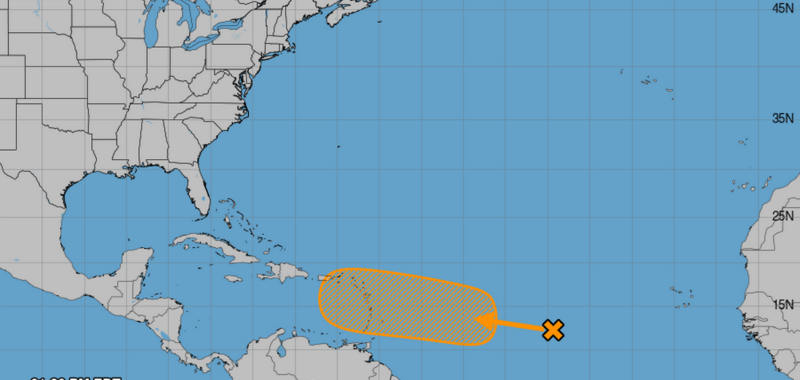
The National Hurricane Center is already eyeing a disturbance in the east Atlantic with a 40% chance of strengthening in the next seven days, even as early as Labor Day weekend. That could put a system near Puerto Rico and Haiti by early next week. And computer models are sniffing out another wave that could be right behind it.
The next name on the list is Francine.
This season got off to a late start with Tropical Storm Alberto at the end of June, but Hurricane Beryl quickly made up for lost time, shredding records left and right as it tore through the Caribbean as a Category 4 hurricane, at one point.
Other than the short-lived Tropical Storm Chris in late June and Category 1 Hurricane Debby a month later, the Atlantic has been largely quiet. The only August storm this year was Hurricane Ernesto, which struck Bermuda as a Category 1.
“Well, it’s a quiet August again. Two years ago we had no storms in August. In fact, we went for 60 days with no development,” said Bryan Norcross, hurricane specialist at Fox Weather. “That was 2022, the year we had Ian.”
Typically, September is the time when we see big, strong storms that form in the far eastern Atlantic and have plenty of time to build up steam over some of the hottest waters all year long before they arrive in the Caribbean or near the east coast. In October, he said, wind patterns over the Atlantic generally shift to make the space less friendly for storm development, so it’s more likely we see storms pop up in the Caribbean or Gulf, with little lead time before they make landfall.
“Writing off the season this early, that’s not reasonable,” he said. “If you lived in a large part of Florida, 2022 was a rip-roaring year and that had zero storms in August.”
A slow August
It’s not exactly clear what’s caused such a prolonged delay in storm activity in what is expected to be one of the busiest seasons on record, but scientists have some theories.
Bell Noll, of New Zealand’s National Institute of Water and Atmospheric Research, noted that the African easterly waves that usually spark the west-tracking hurricanes across the Atlantic this time of year have been misplaced.
Instead of heading from West Africa’s Guinea Highlands into the tropical Atlantic, Noll said they’ve been headed into the Saharan desert, which has seen record-high levels of rain this summer.
“The northward-displaced wave train is one of the factors influencing the current lack of tropical activity in the Atlantic,” he posted on X.
The Atlantic storm factory has also had quite a bit of dry air gumming up the works this month, meteorologist and Weather Tiger founder Ryan Truchelut wrote in a Thursday blog post. He pointed out that the jet stream over the Northeastern Atlantic has dipped repeatedly, delivering gusts of dry air to the northern side of burgeoning tropical waves.
“This is a pretty atypical pattern for the North Atlantic jet stream, but an effective one in suppressing convection, the building blocks from which storms form. It also looks to hold on a bit longer into early September,” he wrote.
Another odd phenomenon that’s captured attention in the Atlantic is sea surface temperatures. After headline after headline earlier this year declaring the ocean was hotter than ever, the charts started to reflect a strange trend — cooling.
A pocket of water near the equator and between Africa and South America started to rapidly cool earlier this month, leading some scientists to predict it could be the start of a weather pattern known as an Atlantic Niña. Some scientists speculated it could have a small influence on the Atlantic storm season, potentially as part of the dampening effect that led to such a quiet August.
However, that pocket is just a small portion of a large and overall hotter-than-usual Atlantic. And just as rapidly as it cooled, it re-warmed, according to a NOAA blog on the subject.
“Even if an Atlantic Niña were to briefly dampen activity, there remain many other factors pushing the basin toward high levels of activity. And even within an active season, there can be periodic lulls in activity. That’s the difference between climate and weather,” the authors wrote.
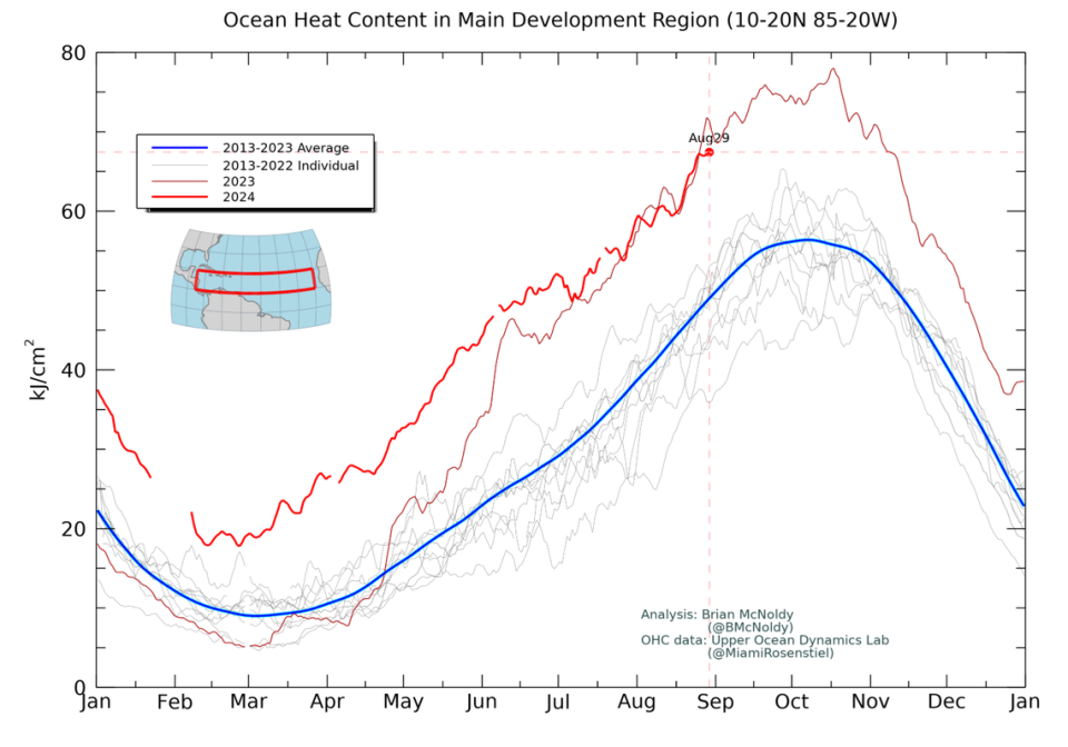
The swath of Atlantic ahead of the disturbance the hurricane center is tracking, or any that may form behind it, is called the main development region. It does not include that cooler-than-average pocket of water.
According to charts maintained by the University of Miami’s Brian McNoldy, ocean heat content in the main development region was still far hotter than average, an ingredient in stronger, faster storm development.